WESTERN ALASKA PARTNERSHIP
  • Home
  • Who we are
    • Mission, Charter & Goals
    • Staff & Steering Committee
  • Our work
    • Overview
    • Coastal
    • Terrestrial
    • Freshwater
  • Opportunities
    • Become a partner
    • Webinars
  • Resources

Coastal Projects

​ShoreZone mapping on the southern Alaska Peninsula

8/1/2019

 
Picture
Mapped features include features such as shore types and morphology (e.g., dunes, beaches, and estuaries), intertidal biota (e.g., salt marshes, eelgrass beds, kelp beds) and man-made features (e.g., seawalls, docks). In addition to the dataset, the web-accessible, high resolution low-tide imagery (video and photos) will complement the mapped data.  The primary project goal is to provide systematic coastal habitat imagery and mapping for the Alaska Peninsula shoreline following the Alaska ShoreZone Mapping Protocol and to make this product web-accessible.  The completed mapping product will be available on the ShoreZone website in a searchable dataset. Individuals and communities will be able to query coastal habitat information for use in coastal zone planning. 

​Project ID: WA2013_27 ​
Lead Investigator: Cindy Hartmann-Moore, NOAA NMFS
Collaborators: Steve Lewis & Mandy Lindeberg, NOAA NMFS; Tina Moran, Leticia Melendez & Danielle Jerry, USFWS; Darren Stewart, The Nature Conservancy; John Harper Coastal and Ocean Resources Inc.; Mary Morris, Archipelago Marine Research, Ltd.
Project Duration: 2013 - 2015
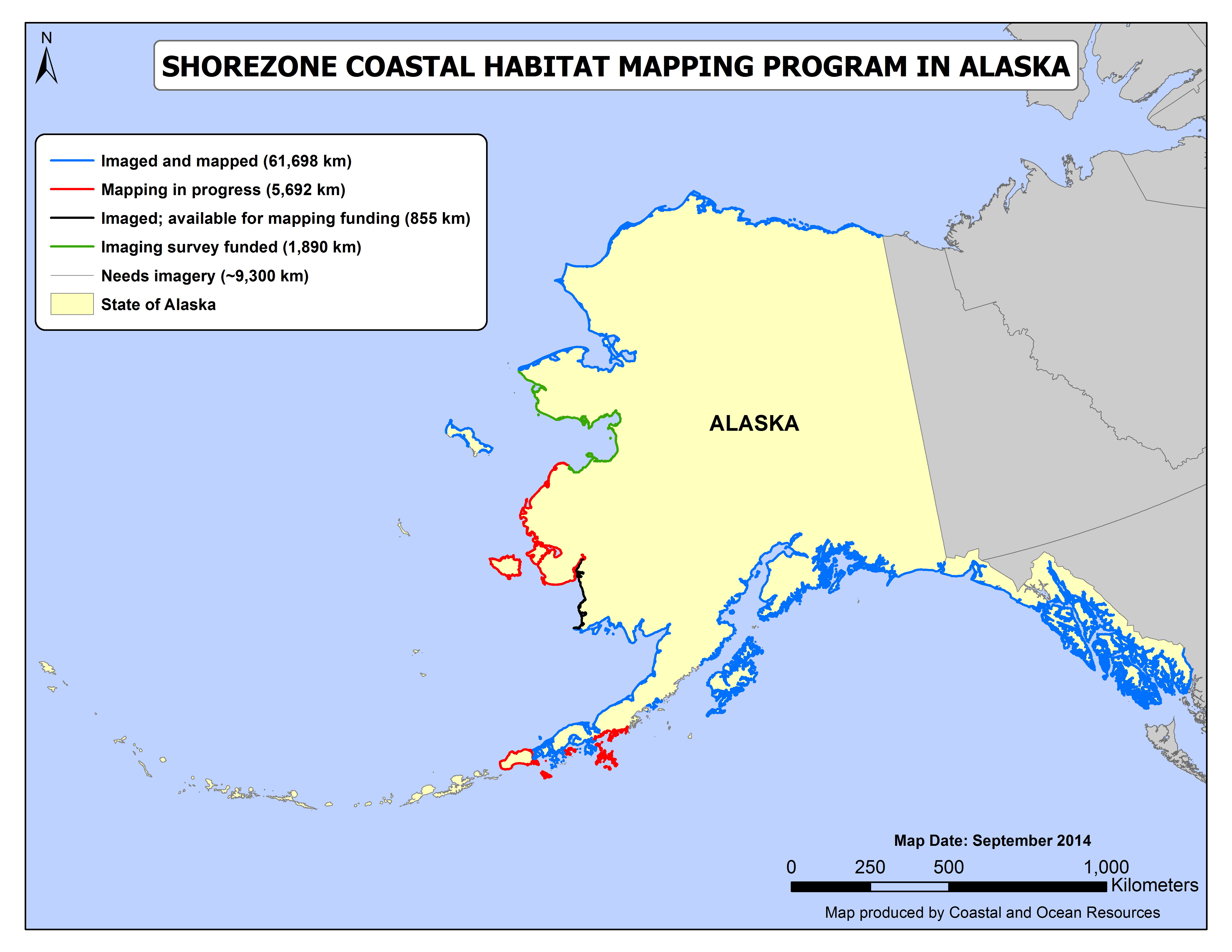
This imagery can be downloaded and is widely used to support agency planning and inventory programs as well as being available to the public to plan their recreational boating or subsistence hunting trips. LCC-funding will contribute to mapping ~1,164 km of shoreline. ​​
Products
Map of Study Area.png
File Size: 338 kb
File Type: png
Download File

Coastal Vulnerability Indices Information.pdf
File Size: 1072 kb
File Type: pdf
Download File

Data Summary Report.pdf
File Size: 6319 kb
File Type: pdf
Download File

Related Resources

Alaska ShoreZone

Alaska ShoreZone's Mapping Website​

Comments are closed.
Proudly powered by Weebly
  • Home
  • Who we are
    • Mission, Charter & Goals
    • Staff & Steering Committee
  • Our work
    • Overview
    • Coastal
    • Terrestrial
    • Freshwater
  • Opportunities
    • Become a partner
    • Webinars
  • Resources